Does This Land Have Legal Access? What Eastern NC Buyers Should Verify
Land & ruralTags:
By Carroll Harrod · Salt & Soil Realty Group
Onslow County GIS is useful for early parcel research, but its mapped boundaries are representations of recorded plats and surveys rather than a substitute for a current field survey. The Onslow County Register of Deeds maintains public real estate records, including deeds and recorded plats. NCDOT also provides tools for researching whether a road is publicly maintained. (Onslow County Maps)
Salt & Soil Realty Group is a real estate brokerage, not a surveyor, engineer, septic installer, or environmental consultant. This post is educational; confirm land, wetland, septic, and access questions with licensed professionals before closing.
See buying land in Eastern North Carolina, usable vs total acreage, and buying land with septic.
Carroll Harrod with Salt & Soil Realty Group helps buyers of land and rural property in Jacksonville, NC, Onslow County, and Coastal North Carolina—including septic, wetlands, and access due diligence.
Does This Land Have Legal Access? What Eastern NC Buyers Should Verify
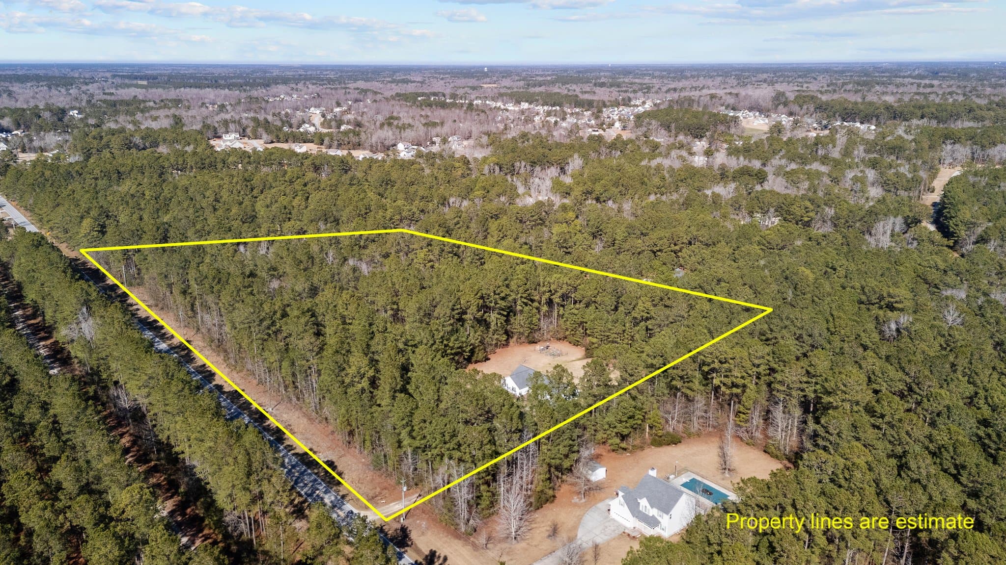
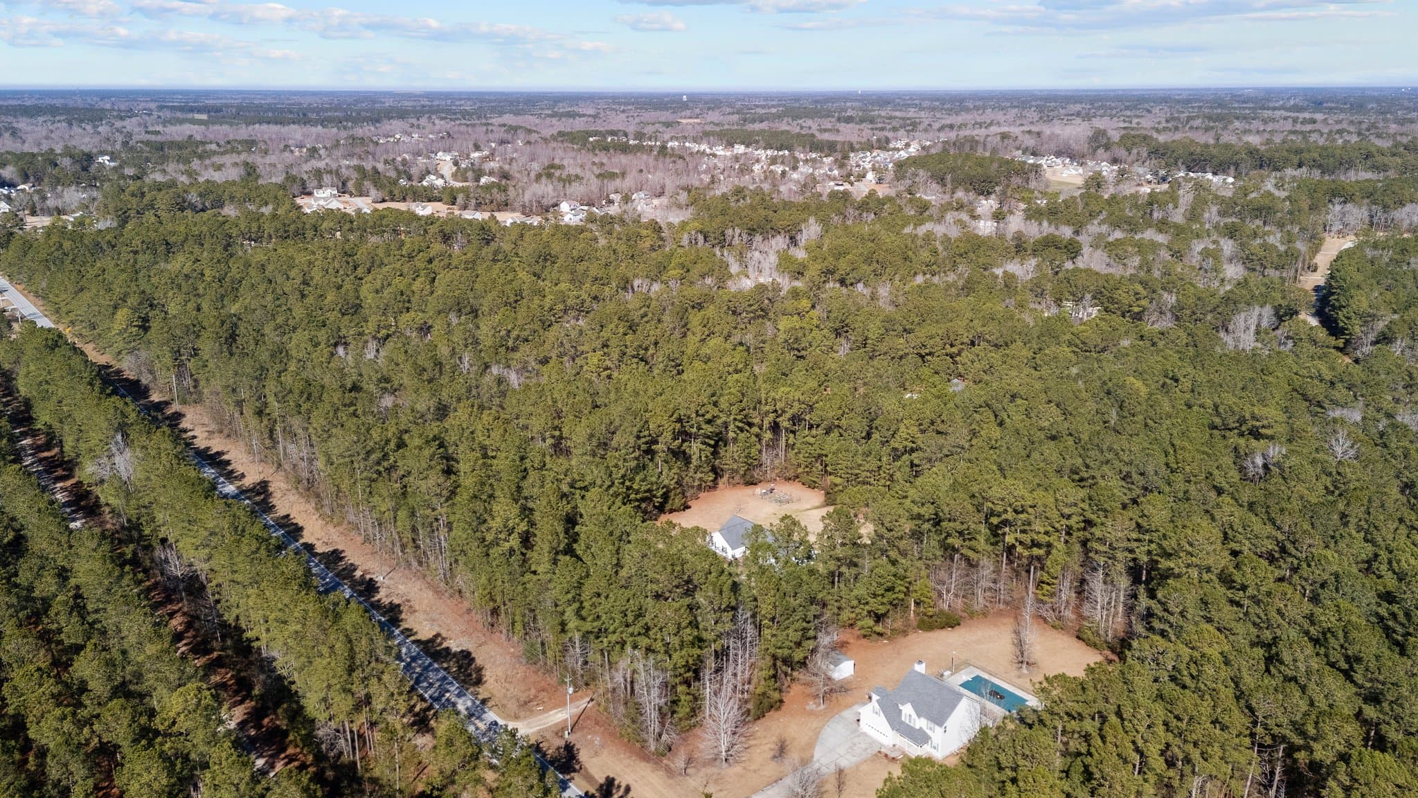
A gravel lane leading into a piece of land can make access look simple.
The driveway is there. The seller uses it. Maybe the neighboring owners have driven across it for years.
But when you are buying land, the practical question is not only whether you can reach the parcel today. You need to know whether you have a documented right to use that route after closing—and whether the road can handle the house, utilities, and construction you have planned.
Access problems are often fixable. They are also much easier to address before you have paid for a survey, soil evaluation, house plans, and site work.
For the broader land-buying process, start with Buying Land in Eastern North Carolina: What to Check Before You Make an Offer.
Public Road Frontage Is Usually the Simplest Setup
A parcel with frontage on a publicly maintained road often gives a buyer the clearest starting point.
That does not mean you can place a driveway anywhere you choose. If the parcel connects to a state-maintained roadway, NCDOT may require a driveway permit for new access or changes to an existing entrance. Sight distance, drainage, culverts, traffic conditions, and the proposed use can affect approval. (Connect NCDOT)
It is also worth confirming who maintains the road rather than relying on the road name, pavement, or appearance. NCDOT’s Public Street Information Database is designed to show road ownership or maintenance status, and its Secondary Roads Lookup can help identify state secondary roads. Both are research tools, so property-specific questions may still require confirmation with NCDOT. (Connect NCDOT)
When a parcel appears to have public frontage, ask:
- How much frontage belongs to the parcel?
- Is the frontage suitable for a driveway?
Will a culvert or permit be required?
- Does a ditch, guardrail, curve, or elevation change complicate access?
- Can construction vehicles enter and turn safely?
A hundred feet of road frontage may sound sufficient until most of it turns out to be deep ditch, wet ground, or poor sight distance.
A Private Road Needs More Than a Handshake
Many rural properties in Eastern North Carolina are reached by private roads. That is not unusual, and a well-documented private road can work perfectly well.
The buyer needs to understand the agreement behind it.
A recorded access easement should identify the land being crossed, the properties that benefit, and the purpose of the easement. The exact wording matters. An attorney should review whether the right transfers with the property and whether it covers the access the buyer expects to use.
This is not a theoretical concern. NCREC has reported cases in which buyers discovered during due diligence that a long private driveway had no written easement or road frontage, after the buyers had already spent money on surveys and other investigations. (NCREC Bulletins)
When land is served by a private road, find out:
- Is the easement recorded?
- Where does it run?
- How wide is it?
- Who has the right to use it?
- Does it reach the parcel being purchased?
- Are gates or access controls involved?
- Can the easement be used for construction traffic?
- Does it include utility installation, or is that addressed separately?
The fact that the current owner has used a road for years does not tell you everything contained in the recorded documents.
Find Out Who Pays for Road Maintenance
A private road has to be maintained by someone.
Gravel needs to be added. Ditches and culverts may need attention. Storms can wash out low sections. Potholes grow, trees fall, and heavy construction equipment can damage a road that was adequate for ordinary vehicles.
A recorded road-maintenance agreement may explain:
- Which owners share responsibility
- How expenses are divided
- Who arranges the work
- What standard of maintenance is required
- How disagreements are handled
Whether one owner has additional obligations
If no agreement exists, ask how maintenance has been handled in practice—but do not treat an informal arrangement as a substitute for legal review.
For newer subdivisions, Onslow County’s subdivision rules distinguish between roads accepted into the state system and private streets transferred for ongoing maintenance. Recorded plats and development documents may therefore contain useful information about who is responsible for the road. (Onslow County)
A private road is not automatically a drawback. A clear agreement and a road that is built for the expected use can make the arrangement straightforward.
Make Sure the Road Works for Construction
A road can be legally adequate and still be physically difficult.
If you plan to build, walk the route with more than an ordinary passenger vehicle in mind. Consider whether concrete trucks, delivery trailers, septic equipment, well-drilling rigs, utility crews, and emergency vehicles can reach the homesite.
Pay attention to:
- Road width
- Overhead branches and power lines
- Sharp turns
- Soft shoulders
- Bridges or pipes
- Culvert capacity
- Weight restrictions
- Low areas that hold water
Space for large vehicles to turn around
NCDOT maintains a database of weight-restricted roads within the state highway system, which can be relevant when heavy vehicles or equipment will be needed. (Connect NCDOT)
Construction access does not need to be perfect when you buy. It needs to be understood and included in the site-development budget.
Do Not Assume the Driveway Easement Covers Utilities
Power, water, internet, or other utility lines may need to cross land you do not own.
Sometimes utility rights run within the same corridor as the private road. In other cases, they are described in a separate easement. Onslow County’s subdivision rules address access and utility easements separately and require utility easements to be configured for the providers that use them. (Onslow County)
That is a good reminder not to assume that the right to drive across a neighbor’s land automatically answers the utility question.
Before making an offer, identify the likely route for power, water, and communications. Then ask the utility provider what rights, clearances, or agreements it will require. Have the recorded documents reviewed if utility installation depends on crossing another parcel.
This question will also connect naturally to the next article in this cluster, which will cover water, power, and internet on rural Eastern North Carolina land.
A Plat, GIS Map, and Survey Are Not the Same Thing
Buyers often look at the county GIS map first. That makes sense. It is a convenient way to see the parcel’s general shape, neighboring ownership, roads, and recorded acreage.
But GIS is not a boundary survey. Onslow County states that its digital parcel information is a representation of recorded plats and surveys maintained for GIS and assessment purposes. (Onslow County Maps)
A recorded plat is also useful, but it may be old. It may show easements, rights-of-way, road widths, and lot dimensions as they were recorded at that time.
A current field survey can help identify conditions on the ground, including:
- Property corners and boundary lines
- Recorded access easements
- Encroachments
- Buildings, fences, and driveways
- Utility corridors
The relationship between improvements and property lines
NCREC cautions that relying on an old survey or seller affidavit may leave buyers exposed to changes or “matters of survey” that a current survey could reveal. (NCREC Bulletins)
The Onslow County Register of Deeds maintains public real estate records, but its staff cannot perform a title search or give legal advice. Your closing attorney and surveyor each have a different role in confirming what the recorded documents and field conditions mean for the purchase. (Onslow County)
Check Access Before Spending Heavily Elsewhere
Access belongs near the beginning of land due diligence.
There is little benefit in ordering house plans or extensive soil work before confirming that the parcel has a usable, documented route to the road. Once access is understood, the driveway, homesite, septic area, and utility plan can be considered together.
Buyers looking at septic-dependent land can continue with Buying Land With Septic in Eastern NC: Soil Evaluations, Bedroom Counts, and Site Planning.
Bottom Line
Legal access and physical access are related, but they are not the same thing.
A buyer needs a documented right to reach the parcel, a clear understanding of who maintains the road, and a route that can support the planned use. Utility access, construction traffic, driveway permits, surveys, and recorded plats all fit into that review.
A private road or easement does not make land a poor purchase. Plenty of excellent rural properties are reached that way. The key is knowing exactly what comes with the land and what will need to be improved.
Salt & Soil Realty Group helps buyers evaluate land and acreage across Onslow County and Eastern North Carolina. Carroll Harrod can help identify access questions early, coordinate them with the larger property plan, and bring in the appropriate surveyor, attorney, contractor, or utility provider before due-diligence deadlines pass.
Frequently Asked Questions
Does a driveway prove that land has legal access?
No. A visible driveway shows how the property is currently reached, but the buyer should still verify public road frontage or a recorded easement. The deed, plat, survey, and title review may all be relevant.
Not necessarily. A private road can work well when the access rights are clear, the road is physically adequate, and maintenance responsibilities are understood. Unclear documentation or no maintenance plan creates more uncertainty.
It depends on the recorded agreements and property arrangement. Maintenance may be assigned to individual owners, shared among users, or handled by an owners’ association. Buyers should review the applicable deeds, plats, covenants, and road-maintenance agreement.
A recorded plat is useful, but it may not show current field conditions or later encroachments. A current survey can help confirm boundaries, easements, access ways, and how existing improvements relate to the property lines.
It depends on the wording of the recorded documents. Road access and utility rights may be addressed together or separately. Have the easement reviewed and confirm the proposed route with the utility provider before assuming lines can be installed.
Research References
Onslow County Real Estate Records
Onslow County Register of Deeds
NCDOT Public Street Information Database
NCREC: Matters of Survey Matter
Onslow County Subdivision Ordinance
Questions about land or rural property in Coastal North Carolina? Contact Salt & Soil Realty Group.